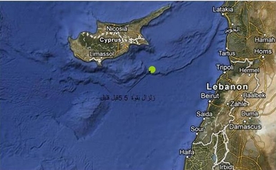
5.5-Magnitude Earthquake on Richter Scale Hits the Area
On Friday, May 11th, a 5.5 magnitude earthquake hit the area at 9:48 local time. Initial data showed that the earthquake’s Focus was relatively deep and its epicenter was 84 km away from Larnaca in Cyprus, and 130 km southwest of Beirut. The earthquake’s coordinates were: 34:17 longitude and 34:30 latitude.
People living in northern West Bank clearly felt the earthquake while those living in central West Bank barely felt the shaking. According to Richter Scale, earthquakes which measure less than 5 on the scale are considered weak or mild, whereas those that register more than 5, in this case 5.5, are considered slightly more serious but do not pose any threat to buildings or constructions.
The Dead Sea area and northern Palestine (Southern Lebanon) has witnessed many minor earthquakes over the last few years, and based on the seismic map of the region, the Dead Sea area, the Jordan Valley, the Lebanese-Syrian borders (Northern Palestine), Bisan, and the Galilee are considered as active seismic regions that have experienced major earthquakes over the course of history.
Dr. Jalal Dabbeek, Director of the Urban Planning and Seismic Engineering Center at An-Najah, said that in order to reduce the risks of seismic disasters there is a need to consider disasters a national priority that is established on a solid executable institutional platform according to clear regulations. This requires reducing the vulnerability of buildings and constructions in Palestine to earthquakes and build the institutions’ and individuals’ capacity to deal with such situations.
For more information about the earthquakes that the region has experienced please refer to the Earthquake Bulletin which is issued by the Seismic Engineering Unit at the University via the following link:
http://www.najah.edu/ar/page/4011
The website also contains many articles, studies and awareness brochures related to earthquakes and the expected seismic behavior of buildings in Palestine.


